Geostatistics
Research topics :
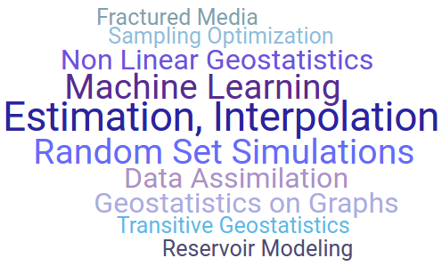
The team has very diverse activities in probability and statistics, traditionally centered on the development of geostatistical methods for many fields of application, and not exclusively in Geosciences.
Team Leader: Nicolas DESASSIS
Administrative Assistant : Nathalie DIETRICH
Researchers: Emilie CHAUTRU – Fabien ORS – Xavier FREULON – Chantal de FOUQUET – Didier RENARD – Thomas ROMARY – Mike PEREIRA
Voluntary Collaborators: Christian LANTUEJOUL – Gaëlle LE LOC’H – Jacques RIVOIRARD – Hans WACKERNAGEL
More info on the Geostatistics team:
– Staff members
– Our publications
– PHD Positions
Team presentation
Geostatistics was founded by Professor Georges Matheron initially to address the estimation issue in mining deposits (see the History of Geostatistics).
Geostatistical methods allow processing spatial data and constitute a part of spatial statistics. They make it possible to represent various phenomena in space and/or time (mapping by kriging, filtering by kriging analysis, conditional simulations, data assimilation) : topography, geological layers, concentration in chemical elements in a mineral deposit or in a polluted site, spatial distribution of geological facies in an oil reservoir, water or air quality, exposure to noise, distribution of fish density, climatological variables, epidemiology factors ... A large number of our publications, book chapters, courses or presentations are available in our online library.
| In recent years, new methodologies have completely modified traditional techniques of geostatistics, such as Stochastic Partial Derivative Equations (SPDE), spatio-temporal processes, machine learning, model inferences, ... The Geostatistical Team is involved in a large choice of trainings (initial training, continuing education and doctoral degrees). It also organizes every two years 'Les Journées de Géostatistique' where a series of presentations on the latest developments in any field of application are presented during 2 days at Fontainebleau. |
Join the team now: Click here [French] |

Main projects
Since its creation, the geostatistical team has contributed to the realization of many projects, either methodological or in applied domains. Many software programs have been created at the Geosciences center.
| gstlearn : The new C++ Library, Python and R packages for Geostatistics | |
| Geolearning is a chair jointly organized with BioSP research unit of MathNum departement at INRAE. Its main goal is to develop methods in geostatistics, extreme event theory and machine learning for data analysis in the service of climate transition. | |
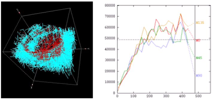
| FLUMY aims at modelizing channelized meandering systems at reservoir scale using the genetic and stochastic approach. These global models simulate deposits associated with meanders and generate 3D blocks conditioned by data. (Platform description sheet) | |
 | The project Kri-Terres (ANR) aims to improve the management of contaminated land by combining kriging and reactive transport simulations. (video of the presentation). |
 | RGeostats : The most complete geostatistical package under R platform |
Application domains
Initially developped for the mining field, geostatistics is now a discipline used in the analysis and management of mineral or renewable resources, environment, climatology, meteorology, ecology but also finance, advanced technologies or even health.
 | 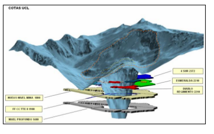 | Mining : estimation of in situ resources, forecast of recoverable reserves above cutoffs, classification of resources, uncertainties on domain limits, taking into account extreme values of grades, impact of spatial sampling on characterization of deposits, uncertainties on reserves ←Modelling the Dyke of the El Teniente mine (Chile) |
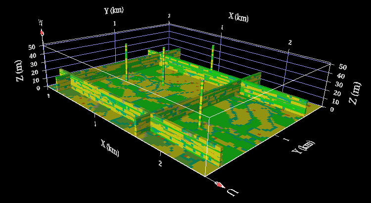 | Oil Industry : modelling the geometry, reservoir characterization, reservoir engineering, seismic. ←Example of a reservoir simulate using Flumy Geological layer cake → | 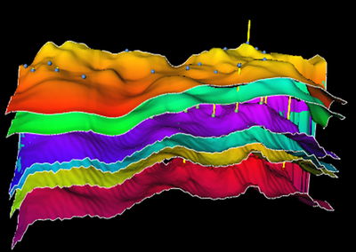 |
| Fisheries : fish density, species migration Sardine population in the Bay of Biscay→ | 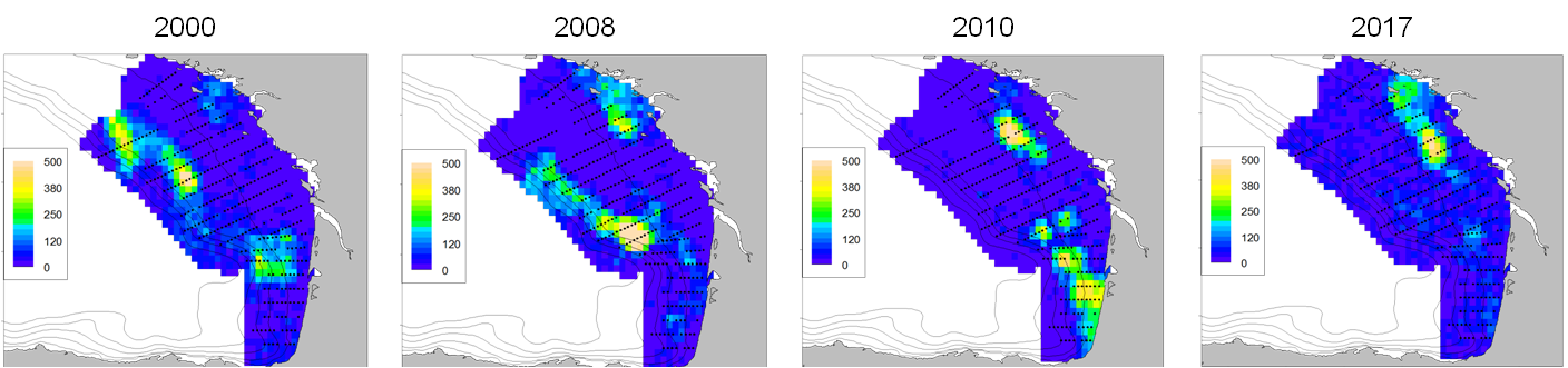 | |
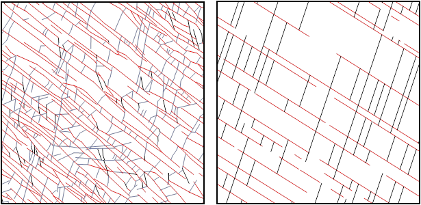 | Fractured media : blocometry, determination of percolation thresholds, calculation of equivalent permeability ←Tayma's hierarchical fracture model Fractured carbonate reservoir→ | 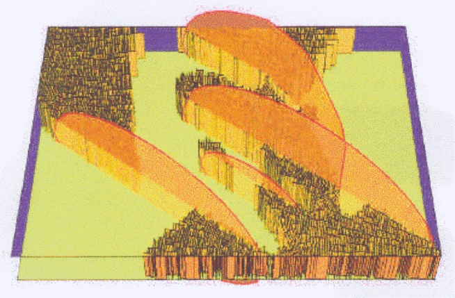 |
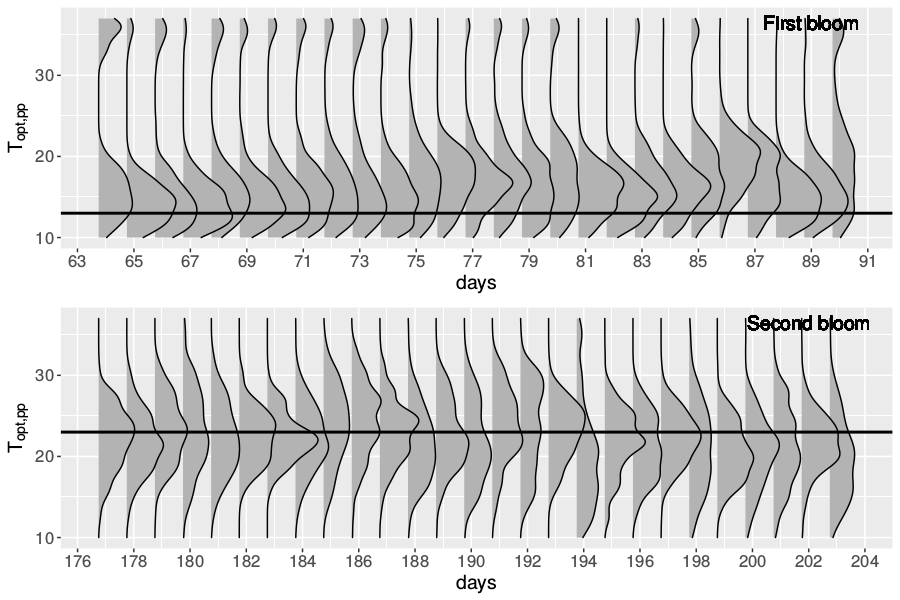 | Environment : air quality, pollution maps (bottom or proximity), rivers and aquifers (concentrations of pollutants along rivers), soils and sediments, climatology, CO2 concentration ←Optimal phytoplankton growth temperature Simulation of the extension of a tritium plume→ | 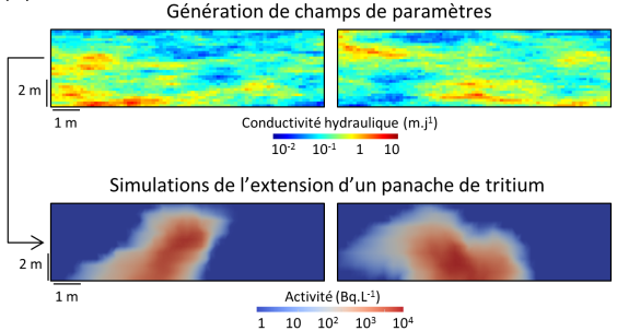 |
| Oceanography : seabed mapping, temperature or salinity maps, ice thickness Temperature mapping at 25m depth off the coast of Norway→ | 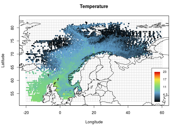 | 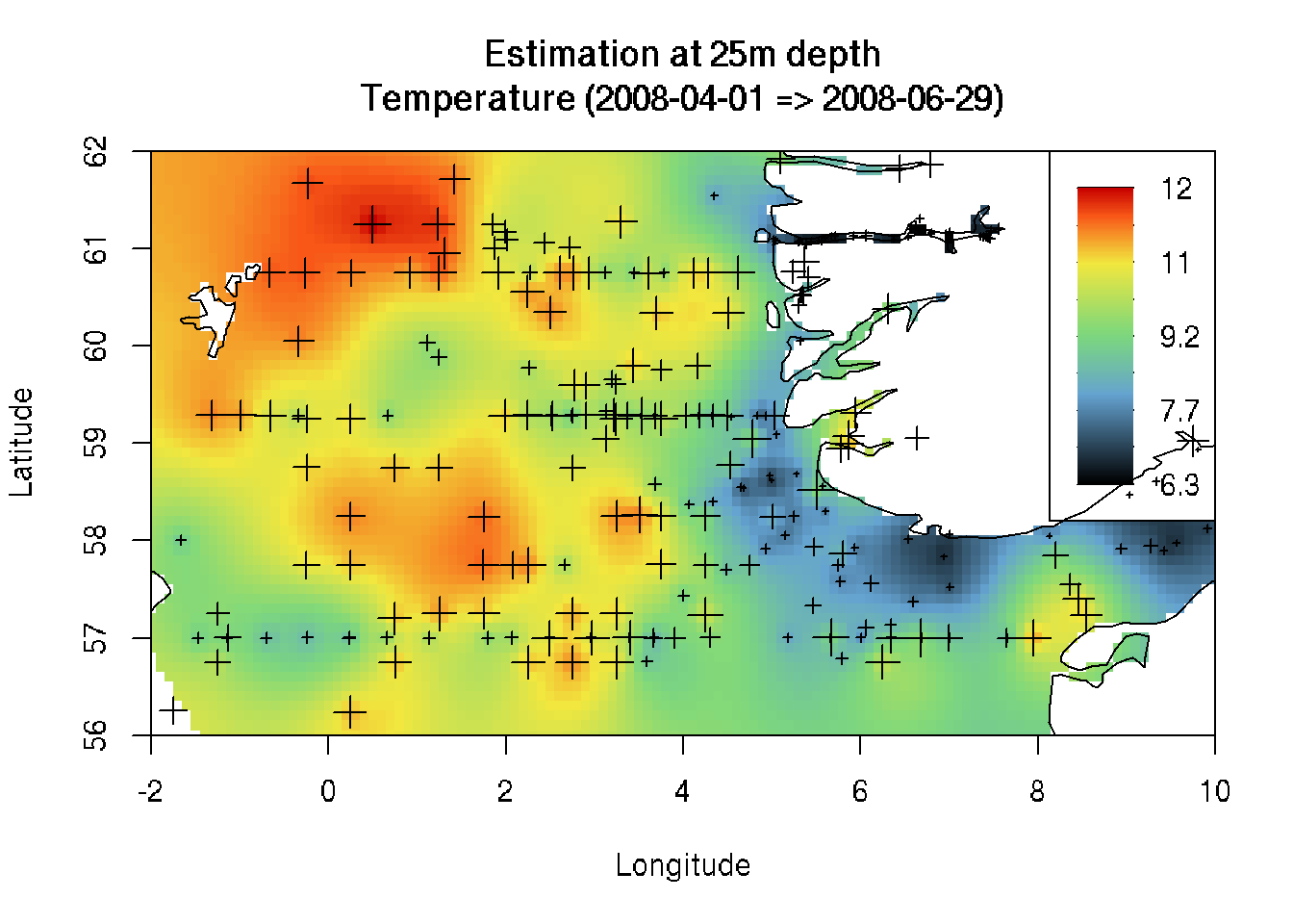 |
 | Health : epidemiology, industrial hygiene, exposure to radio waves ←Map of exposure to radio waves in a district of Grenoble 1988/1989 flu epidemic in France → | 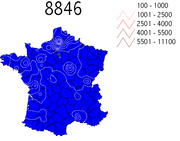 |
| and also : - Hydrogeology and Geotechnics, - Agronomy, - Demographic modeling, - Modeling and evaluation of the performance of a distribution network, - Insurance risk assessment | ||
PhD and postdoctoral studies
Ongoing
Quantification of devastating climate events under climate change through novel multivariate bias correction methods. Grégoire Jacquemin
Caractérisation radiologique de sites contaminés à partir de reconnaissances à différentes échelles. Meryem MEZIANE
Domain modeling using artificial intelligence guided by geological constraints. Charlie GARAYT
High Frequency Data Assimilation in Prose-PA water quality model. Masihullah HASANYAR
Contribution of geostatistics in forensic science to the identification of the origin of traces of soil. Amélie DEVRESSE
Urban Mining and WEEE sampling. Alexis BARTHET
Development of geostatistical spatio-temporal methods of simulations using generative models of deep learning. Ferdinand BHASVAR
Defended in 2019, 2020, 2021, 2022 or 2023
Modelling Insurable Values. Luc RONGIERAS
Spatio-temporal prediction by stochastic partial differential equations. Lucia CLAROTTO
Geostatistical modelling of geotechnical variables. Katherine SANCHEZ
Conditional simulation of process-based reservoir models by sequential Monte Carlo techniques (SMC). Alan TRONCOSO MORALES
Machine learning for the quality control of seismic data. Mathieu CHAMBEFORT
On the conditioning of process-based channelized meandering reservoir models on well data. Anna BUBNOVA
Uncertainty quantification in an uranium ore deposit exploitation by In Situ Recovery. Jean LANGANAY
Combining geostatistics and physically-based simulations – application to the characterization of contaminant plumes Léa PANNECOUCKE
Spatial extremes with a single realization: a geostatistical point of view. Marine DEMANGEOT
Generalized random fields on Riemannian manifolds : theory and practice: théorie et pratique. Mike PEREIRA
Constitution of local geochemical references for urban soils and subsoils : from database to geostatistical interpretation. Baptiste SAUVAGET